
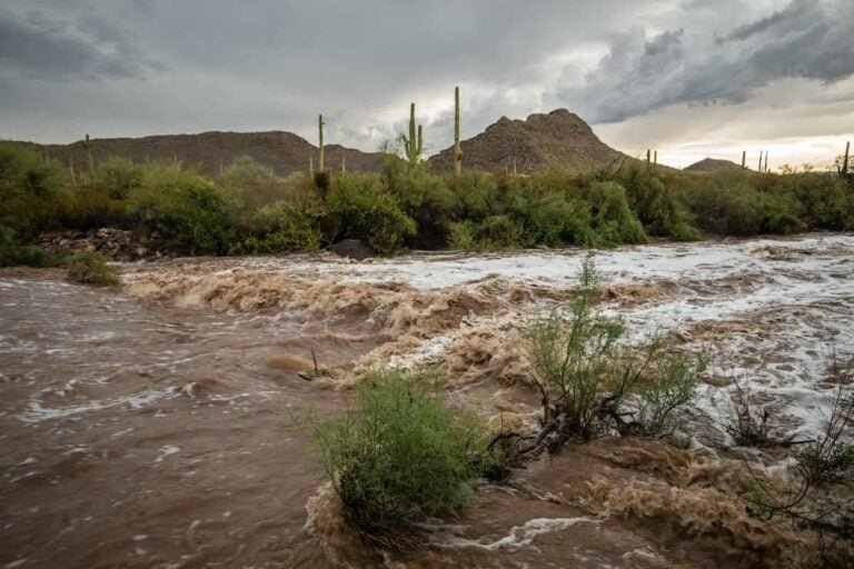


Southwest communities already soaked by weeks of storms faced another round of dangerous flooding as heavy rain moved through the region from Saturday evening, 31 October, through Monday, 2 November. The National Weather Service warned that additional rainfall could trigger flash floods and rising waterways across the Southwest, in Arizona, Nevada, Utah, Colorado, and New Mexico. Flood watches covered nearly all of Arizona, parts of southern Utah, southwestern Colorado, western New Mexico, and southern Nevada, including the Four Corners region where Arizona, Colorado, New Mexico, and Utah meet.
The threat was serious because the ground could take in little more water. Forecasters estimated that some locations could receive up to 4 inches of rain, and the Weather Prediction Center said that amount was enough to produce flash flooding because soils and channels were already near capacity. Allison Santorelli, a meteorologist with the Weather Prediction Center in College Park, Maryland, warned that saturated ground could make even moderate rainfall dangerous. She said it was not going to take much rainfall to be impactful at all in some locations just because of how saturated they were.
The region had already endured a deadly autumn of soaking rains, with a number of weather systems bringing repeated downpours to the same areas. Several people were rescued from floodwaters on Friday in Arizona and Nevada, before the weekend system arrived. A Scottsdale fire captain noted that as little as 2 inches of moving water can carry a vehicle, and recent rescues involved water depths of about 3 to 4 feet. Officials urged drivers not to test flooded roads, even where the water looked shallow.
Southwest rainfall totals forecast for Arizona
The heaviest rain was expected in Arizona, especially across central and northern parts of the state. Rainfall totals across central and northern Arizona were generally forecast at 1.75 to 4 inches, with portions of the eastern Mogollon Rim and surrounding higher terrain possibly receiving 3.5 to 6 inches or more where persistent rain bands developed. Across the Phoenix metropolitan area and surrounding foothills, about 1.5 to 3.5 inches was possible, while southern and southeastern Arizona could receive about 0.5 to 1.75 inches, with higher amounts in thunderstorms.
The Weather Prediction Center placed the Four Corners under a Moderate Risk of excessive rainfall for 1 November, when it expected a high impact heavy rainfall event over saturated ground. A Moderate Risk means at least a 40 percent probability of rainfall exceeding flash flood guidance within 25 miles of a point. Slight Risk areas covered portions of Arizona, southern Utah, and southwestern New Mexico. Forecasters said scattered to numerous thunderstorms were expected mainly from central into eastern Arizona.
Southwest flood danger in washes and canyons
The expected rainfall could produce both sudden flash flooding and flooding along smaller rivers and streams. Forecasters warned of rapidly rising washes, overflowing creeks and rivers, and dangerous runoff over ground that was already wet. The danger was highest in low lying areas, slot canyons, burn scars, dry washes, and low water crossings. Persistent rain bands could produce local totals considerably higher than surrounding areas, particularly across Arizona mountainous terrain, with embedded thunderstorms increasing rainfall intensity on Sunday.
Areas in Utah and Colorado faced another significant round of rain on Sunday through Monday as the Pacific storm moved inland and met colder air. Across Utah, totals were generally forecast at 0.75 to 3 inches, with southern and eastern portions facing a higher flash flooding concern, particularly around washes, slot canyons, and areas that had already received substantial rain. The National Weather Service office in Grand Junction forecast 1 to 3 inches across parts of southeastern Utah and southwestern Colorado from 1 into 2 November, with a flood watch covering the Four Corners, the Upper Dolores, Animas, and San Juan river basins, and parts of southeastern Utah.
Southwest snow and travel disruption in Colorado
Higher elevations in the Southwest, in Colorado’s San Juan Mountains, faced a change from heavy rainfall to substantial snowfall. Forecasts cited by the National Weather Service indicated accumulations of 12 to 18 inches, potentially creating hazardous travel conditions along southwestern mountain roads. Snow levels were forecast to rise above about 11,000 feet, leaving most middle elevations and valleys exposed to heavy rain.
Southern California faced mainly light to moderate showers, while the main rain threat stayed farther east. Fox Weather put a low level flash flood threat for nearly 40 million people extending from Texas to Wisconsin, a wider footprint than the Southwest watches alone. Residents across the region were urged to follow National Weather Service and local emergency updates, to avoid flooded roads, and to watch for closures as water levels rose. The primary impacts were expected from Saturday evening through Sunday night, with lingering flooding and elevated water levels continuing into Monday.